-

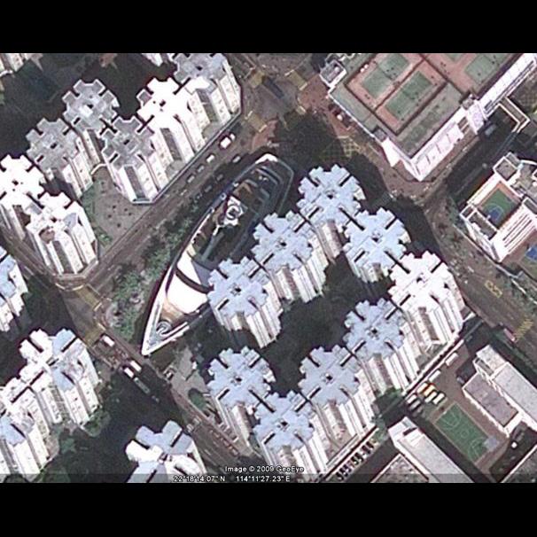
A dry-docked skiff is one thing, but a cruise ship parked between skyscrapers in the middle of a city is quite another (22°18'14.15"N, 114°11'24.66"E) ([[xref:http://maps.google.com/maps?f=q&source=s_q&hl=en&geocode=&q=22%C2%B018%2714.15%22N,+114%C2%B011%2724.66%22E&sll=51.321668,6.576626&sspn=0.000236,0.000603&ie=UTF8&ll=22.303917,114.190038&spn=0.005578,0.009645&t=h&z=17|see it in Google Maps]]). This ocean liner is known by locals as Whompoa Boat and doubles as a shopping mall in downtown Hong Kong.
-
Strangest Sights in Google Earth
In the olden days, the ancients recognized [[xref:http://en.wikipedia.org/wiki/Seven_Wonders_of_the_Ancient_World|Seven Wonders of the World]]; but thanks to Google Earth, you can now spot thousands of "I wonder what it is" head scratchers. Among the new wonders: a 1-square-mile painting of a cowboy's head, a giant cruise ship parked between skyscrapers, and places that look, well, not of this world.
Three years ago, when we originally attempted to identify The [[xref:http://www.pcworld.com/article/134186/in_pictures_the_strangest_sights_in_google_earth.html|Strangest Sights in Google Earth]], we thought we'd seen them all. But in reality, we were just getting started. Here we've collected more Google Earth mysteries. By clicking the links provided with each slide you can visit each sighting in Google Maps. But for better viewing results, we encourage you to visit the destinations in Google's free mapping software Google Earth. We've included the coordinates in parenthesis next to each sighting so you can cut and paste those coordinates into Google Earth's 'Fly To' box. We've also created a "zoom to image" option for other Google Earth images mentioned in the slideshow text, so you can view sites without leaving the slideshow. Enjoy your trip! -
Standing in front of China's Beijing South Railway Station must be impressive, but seeing it from the perspective of the Google Earth satellite is cool, too (39°51'50.35"N, 116°22'21.78"E) ([[xref:http://maps.google.com/maps?f=q&source=s_q&hl=en&geocode=&q=39%C2%B051%2750.35%22N,+116%C2%B022%2721.78%22E&sll=25.141917,55.184656&sspn=0.021833,0.038581&ie=UTF8&t=h&z=16|see it on Google Maps]]). From above, this ultramodern railway station looks like a cat's eye. For larger-than-life architectural finds, nothing beats Google Earth for getting a grand perspective.
-
This aerial shot of an Algerian desert (31° 7'45.56"N, 7°56'23.12"E) looks like something taken by a satellite orbiting Mars. The stunning alien-like landscape has inspired some Google Earth daydreamers to spot images of girl's face (31°15'14.82"N, 7°53'12.10"E) ([[xref:http://maps.google.com/maps?f=q&source=s_q&hl=en&geocode=&q=&sll=31.254285,7.886821&sspn=0.005155,0.009645&ie=UTF8&ll=31.254285,7.886821&spn=0.005155,0.009645&t=h&z=17|see it on Google Maps]]) or a tree (30°56'55.41"N, 7°52'51.37"E) ([[xref:http://maps.google.com/maps?f=q&source=s_q&hl=en&geocode=&q=&sll=30.94896,7.881446&sspn=0.010342,0.01929&ie=UTF8&ll=30.94896,7.881446&spn=0.010342,0.01929&t=h&z=16|see it on Google Maps]]) between the wavy sandy crevasses. Think Algeria looks other-worldly? Try these mud flats (39.094361,83.596134) ([[xref:http://maps.google.com/maps?f=q&source=s_q&hl=en&geocode=&q=&sll=39.093865,83.593211&sspn=0.018719,0.038581&ie=UTF8&ll=39.093865,83.593211&spn=0.018719,0.038581&t=h&z=15|see it in Google Maps]]) found in a remote part of Sinkiang, China, and this beadlike tableau (17°25'42.01"N, 6°38'30.39"E) ([[xref:http://maps.google.com/maps?f=q&source=s_q&hl=en&geocode=&q=&sll=17.428357,6.641787&sspn=0.00036,0.000603&ie=UTF8&ll=17.428357,6.641787&spn=0.00036,0.000603&t=h&z=21|see it in Google Maps]]) in the Agadez region of Niger, where salt production has created odd formations in the landscape.
-
The artist Ando doesn't just think big--he thinks humongous. Using 1 square mile of Australian Outback as his canvas, Ando "painted" a picture of a cowboy into the landscape. Called [[xref:http://www.andoart.com/eldee.htm|Mundi Man or Eldee Man]], it is located on the Mundi Plains in Australia (31°40'37.11"S, 141°14'23.68"E) ([[xref:http://maps.google.com/maps?f=q&source=s_q&hl=en&geocode=&q=&sll=-31.67758,141.239419&sspn=0.010263,0.01929&ie=UTF8&ll=-31.67758,141.239419&spn=0.010263,0.01929&t=h&z=16|see it in Google Maps]]) and is meant to represent the people who pioneered in the region. The image here has been color-adjusted for clarity. (The additional image here is from AndoArt.com.) And could this be the cowboy's footprint (51.294076,-1.534722) ([[xref:http://maps.google.com/maps?f=q&source=s_q&hl=en&geocode=&q=&sll=51.293894,-1.534191&sspn=0.00377,0.009645&ie=UTF8&ll=51.294141,-1.53483&spn=0.000943,0.002411&t=h&z=19|see it in Google Maps]]), or his thumbprint (50.844,-0.172043) ([[xref:http://maps.google.com/maps?f=q&source=s_q&hl=en&geocode=&q=&sll=50.845128,-0.172465&sspn=0.007614,0.01929&g=50.844,-0.172043&ie=UTF8&ll=50.844087,-0.172166&spn=0.000476,0.001206&t=h&z=20|see it in Google Maps]])?
-
Whether parked, crashed, or flying, airplanes are among the most sought-after and collected finds in Google Earth. Here is the mammoth airplane graveyard at Davis-Monthan Air Force Base (32° 9'1.75"N, 110°49'56.57"W) ([[xref:http://maps.google.com/maps?f=q&source=s_q&hl=en&geocode=&q=&sll=32.167348,-110.858445&sspn=0.010208,0.01929&ie=UTF8&ll=32.166349,-110.856771&spn=0.010208,0.01929&t=h&z=16|see it in Google Maps]]) in Tucson, Arizona. You might ask, why should a good airplane go to waste? Some people agree with you--[[:http://www.airplanehome.com/|like these folks]] (45°24'28.71"N, 123° 0'28.23"W) ([[xref:http://maps.google.com/maps?f=q&source=s_q&hl=en&geocode=&q=45%C2%B024%2728.71%22N,+123%C2%B0+0%2728.23%22W&sll=37.645358,-115.749738&sspn=0.009549,0.01929&g=37%C2%B038%2747.40%22N,+115%C2%B045%271.27%22W&ie=UTF8&ll=45.407874,-123.007688&spn=0.002117,0.004823&t=h&|see it in Google Maps]]) who live in Washington state and couldn't bear to see perfectly good Boeing 727 go to waste: They made a home out of it.
-
If alien visitors happen to land in Rachel, Nevada, don't be surprised if they think Colonel Sanders is our leader. That town has an 87,500-square-foot image of the smiling Colonel (37°38'47.40"N, 115°45'1.27"W) ([[xref:http://maps.google.com/maps?f=q&source=s_q&hl=en&geocode=&q=37%C2%B038%2747.40%22N,+115%C2%B045%271.27%22W&sll=42.00754,-87.885711&sspn=0.00448,0.009645&ie=UTF8&t=h&z=16|see it in Google Maps]]) composed of 65,000 one-foot-square tiles, [[xref:http://en.wikipedia.org/wiki/KFC|according to reports]]. This KFC logo is part of a larger trend called [[xref:http://www.artfield.de/landartfield.html|mapvertising]], in which companies create product logos that are visible from space (or from planes landing at Chicago O'Hare Airport (42° 0'28.67"N, 87°53'9.89"W) ([[xref:http://maps.google.com/maps?f=q&source=s_q&hl=en&geocode=&q=42%C2%B0+0%2728.67%22N,+87%C2%B053%279.89%22W&sll=22.303917,114.190038&sspn=0.005578,0.009645&ie=UTF8&ll=42.00754,-87.885711&spn=0.00448,0.009645&t=h&z=17|see it in Google Maps]]). A [[xref:http://www.youtube.com/watch?v=fsH4gws35ro|video of the making of the giant-size Colonel Sanders has been posted to YouTube]].
-
You've probably heard of cow tipping, but what about car tipping? To judge from this photo, a dearth of cows in the Netherlands has inspired people to begin tipping parked cars instead (51°19'18.13"N, 6°34'35.64"E) ([[xref:http://maps.google.com/maps?f=q&source=s_q&hl=en&geocode=&q=51%C2%B019%2718.13%22N,++6%C2%B034%2735.64%22E&sll=37.0625,-95.677068&sspn=39.047881,79.013672&ie=UTF8&ll=51.321668,6.576626&spn=0.000236,0.000603&t=h&z=21|see it in Google Maps)]].
-
Need an island, but can't find one to buy? Why not build one? That appears to be the philosophy behind islands being built in Dubai, United Arab Emirates, in the shape of palm trees crowned with crescents. This image shows one (25° 7'2.64"N, 55° 7'59.28"E) ([[xref:http://maps.google.com/maps?f=q&source=s_q&hl=en&geocode=&q=25%C2%B0+7%272.64%22N,+55%C2%B0+7%2759.28%22E&sll=41.891035,12.492441&sspn=0.008977,0.01929&gl=us&ie=UTF8&t=h&z=16|see it in Google Maps]]) of three identical Palm Islands being built from an estimated [[xref:http://en.wikipedia.org/wiki/Palm_Islands|500,000 cubic meters of rock and sand]]. Google Earth offers a unique way to explore this island, serving up a high-resolution map where you can wander the island's 100 luxury hotels, water parks, and lavish homes.
-
Sure, visiting breathtaking landmarks such as the Roman Coliseum (41°53'26.44"N, 12°29'31.17"E) ([[xref:http://maps.google.com/maps?f=q&source=s_q&hl=en&geocode=&q=41%C2%B053%2726.44%22N,+12%C2%B029%2731.17%22E&sll=36.098594,-112.092946&sspn=0.019488,0.038581&gl=us&ie=UTF8&t=h&z=16|see it in Google Maps]]) in person is the best way to see them. (Shown in the inset at bottom left is a [[xref:http://www.pcworld.com/article/161392-13/strangest_sights_in_google_street_views.html|Google Street View of the Roman Coliseum]]--another alternative for virtual globetrotters.) But if your budget and schedule don't permit it, Google Earth may just have to do. The good news for virtual tourists is that Google has updated its coverage of many of the world's most popular destinations with high-resolution images that make an Internet trip to the Grand Canyon (36.102966,-112.091532 ) ([[xref:http://maps.google.com/maps?f=q&source=s_q&hl=en&geocode=&q=36.102966,-112.091532&sll=36.105705,-112.145004&sspn=0.019486,0.038581&gl=us&ie=UTF8&t=h&z=15|see it in Google Maps]]), the Great Wall of China (40°21'15.86"N, 116° 0'25.31"E) ([[xref:http://maps.google.com/maps?f=q&source=s_q&hl=en&geocode=&q=40%C2%B021%2715.86%22N,+116%C2%B0+0%2725.31%22E&sll=48.85772,2.293718&sspn=0.003967,0.009645&gl=us&ie=UTF8&ll=40.354349,116.007455&spn=0.002297,0.004823&t=h&z=18|see it in Google Maps]]), and Eiffel Tower (48°51'29.47"N, 2°17'40.26"E) ([[xref:http://maps.google.com/maps?f=q&source=s_q&hl=en&geocode=&q=48%C2%B051%2729.47%22N,++2%C2%B017%2740.26%22E&sll=40.457397,93.4025&sspn=0.036703,0.077162&gl=us&ie=UTF8&ll=48.85772,2.293718&spn=0.003967,0.009645&t=h&z=17|see it in Google Maps]]) as enjoyable as possible.
-
What's the purpose of the mammoth designs painted onto the floor of a Chinese desert?(40°27'4.87"N, 93°44'42.90"E) ([[xref:http://maps.google.com/maps?f=q&source=s_q&hl=en&geocode=&q=40%C2%B027%2723.66%22N,+93%C2%B023%277.78%22E&sll=40.456572,93.385494&sspn=4.697754,9.876709&gl=us&g=40%C2%B027%2723.66%22N,+93%C2%B023%277.78%22E&ie=UTF8&ll=40.457397,93.4025&spn=0.036703,0.077162&t=h&z=|see it in Google Maps]]). Perhaps only the Chinese military knows. That's who some people speculate is behind not several (40°27'23.66"N, 93°23'7.78"E) similar mile-wide paintings. A nearby Stonehenge-looking formation (40°27'31.04"N, 93°18'47.21"E) ([[xref:http://maps.google.com/maps?f=q&source=s_q&hl=en&geocode=&q=40%C2%B027%2731.04%22N,+93%C2%B018%2747.21%22E&sll=52.482205,0.521625&sspn=0.003672,0.009645&gl=us&ie=UTF8&ll=40.458446,93.31337&spn=0.002294,0.004823&t=h&z=18|see it in Google Maps]]) with three jets parked in the middle suggests a possible military purpose to the enterprise. But giant white lines etched into the Earth are not unique to just China. A mysterious pattern of white lines found in Norwich, UK (52.481725, 0.520627) ([[xref:http://maps.google.com/maps?f=q&source=s_q&hl=en&geocode=&q=52.481725,+0.520627&sll=27.380266,33.632814&sspn=0.002677,0.004823&gl=us&ie=UTF8&ll=52.482205,0.521625&spn=0.003672,0.009645&t=h&z=17|see it on Google Maps]]) has prompted some Fox Mulder fans to say [[xref:http://en.wikipedia.org/wiki/The_X-Files:_I_Want_to_Believe|"I want to believe."]]
-
Instead of working with paint brushes and canvases, [[xref:http://en.wikipedia.org/wiki/Installation_art|some artists]] use bulldozers and backhoes to create art. In their 1997 desert installation called Desert Breath (27°22'50.10"N, 33°37'54.62"E) ([[xref:http://maps.google.com/maps?f=q&source=s_q&hl=en&geocode=&q=27%C2%B022%2750.10%22N,+33%C2%B037%2754.62%22E&sll=22.432877,91.728598&sspn=0.005573,0.009645&gl=us&ie=UTF8&ll=27.380266,33.632814&spn=0.002677,0.004823&t=h&z=18|see it on Google Maps]]), artists Danae Stratou, Alexandra Stratou, and Stella Constantinides created two interlocking spirals that stretch almost 0.25 mile from side to side in the Egyptian desert. The inset images on the left are from [[xref:http://www.danaestratou.com/|DanaeStratou.com]] and show Desert Breath just after it was completed and before the installation was ravaged by wind, rain, and time.
-
This satellite view of what CBS news called "hell on earth" in a [[xref:http://www.cbsnews.com/stories/2006/11/03/60minutes/main2149023.shtml|60 Minutes exposé]] is as close as you might want to get to the beach of Bhatiari, Bangladesh ( 22°26'4.44"N, 91°43'46.32"E) ([[xref:http://maps.google.com/maps?f=q&source=s_q&hl=en&geocode=&q=22%C2%B026%274.44%22N,+91%C2%B043%2746.32%22E&sll=43.978528,15.383372&sspn=0.017356,0.038581&gl=us&g=43%C2%B058%2742.70%22N,+15%C2%B023%270.14%22E&ie=UTF8&ll=22.432877,91.728598&spn=0.005573,0.009645&t=h&|see it on Google Maps]]), where hundreds of cashiered luxury liners and no-longer-useful cargo ships come to die and be dismembered.What you can't see in this satellite snapshot are the thousands of workers who get paid a dollar a day to toil in the heat and toxic boat waste salvaging steel, copper, and ship parts. The inset image on the right of the slide is from [[xref:http://www.flickr.com/photos/30088500@N00/2316285684/|Flickr user naquib]]. And speaking of maritime graveyards, here is where U.S. Navy mothballs some of its fleet near Benicia, California (38° 3'55.21"N 122° 6'15.96"W) ([[xref:http://maps.google.com/maps?f=q&source=s_q&hl=en&geocode=&q=&sll=38.064691,-122.104878&sspn=0.002374,0.004823&ie=UTF8&ll=38.064691,-122.104878&spn=0.002374,0.004823&t=h&z=18|see it in Google Maps]]).
-
How does Mother Earth show her love for Google Earth? With heart-shaped islands (43°58'42.70"N, 15°23'0.14"E) ([[xref:http://maps.google.com/maps?f=q&source=s_q&hl=en&geocode=&q=43%C2%B058%2742.70%22N,+15%C2%B023%270.14%22E&sll=52.257474,10.521764&sspn=0.001845,0.004823&gl=us&ie=UTF8&t=h&z=15|see it on Google Maps]]), ponds (52°15'27.48"N, 10°31'17.62"E) ([[xref:http://maps.google.com/maps?f=q&source=s_q&hl=en&geocode=&q=52%C2%B015%2727.48%22N,+10%C2%B031%2717.62%22E&sll=-20.938415,164.658515&sspn=0.005631,0.009645&gl=us&ie=UTF8&ll=52.257474,10.521764&spn=0.001845,0.004823&t=h&z=18|see it on Google Maps]]), and botanical enigmas (20°56'15.47"S, 164°39'30.56"E) ([[xref:http://maps.google.com/maps?q=20%C2%B056%2715.47%22S,+164%C2%B039%2730.56%22E&ie=UTF8&hq=&hnear=-20%C2%B0+56%27+15.47%22,+%2B164%C2%B0+39%27+30.56%22&gl=us&ei=dt3ZS_riG8L78AaHw4hg&ved=0CAoQ8gEwAA&ll=-20.938415,164.658515&spn=0.005631,0.009645&t=h&z=17|see it on Google Maps]]), of course. How do mere mortals show their love for Google Earth? We etch our devotion into Mother Earth via heart-shaped designs (48°53'26.45"N, 12°30'36.01"E) ([[xref:http://maps.google.com/maps?f=q&source=s_q&hl=en&geocode=&q=48%C2%B053%2726.45%22N,+12%C2%B030%2736.01%22E&sll=37.0625,-95.677068&sspn=39.047881,79.013672&ie=UTF8&ll=48.890399,12.510011&spn=0.001982,0.004823&t=h&z=18|see it on Google Maps]]), of which [[xref:http://www.geo-trotter.com/cat-coeur.php|there are plenty]].
-
Since [[xref:http://blogs.pcworld.com/techlog/archives/000748.html|Google Earth debuted in 2005]], the satellite images accessible through the mapping software have gotten sharper. Sometimes you can be caught off guard by stunningly crisp images of random things. Here is an image of a park in Sebastopol, California, where people are lounging on the grass and others are lining up for lunch (38°24'40.50"N, 122°50'25.42"W) ([[xref:http://maps.google.com/maps?hl=en&q=38%C2%B024%2740.50%22N,+122%C2%B050%2725.42%22W&ie=UTF8&hq=&hnear=%2B38%C2%B0+24%27+40.50%22,+-122%C2%B0+50%27+25.42%22&gl=us&ei=P9nZS8q4PJKI8wTW3JRH&ved=0CAgQ8gEwAA&ll=38.411257,-122.840405&spn=0.000523,0.001206&t=h&z=2|see it on Google Maps]]; to see this image on the resulting map, move the slider bar all the way to the highest magnification, next to the + label). What gives? According to unconfirmed reports, this is a meeting of [[xref:http://en.wikipedia.org/wiki/Foo_Camp|Foo Camp]], an annual hacker conference sponsored by O'Reilly Media. Another seemingly random high-resolution image captures a lonely Land Rover driving through a Moroccan desert (27°56'25.44"N, 12°17'28.15"W). Other spectacular high-resolution images, like these pyramids located outside of Cairo, Egypt (29°58'44.64"N, 31° 7'54.60"E) ([[xref:http://maps.google.com/maps?f=q&source=s_q&hl=en&geocode=&q=29%C2%B058%2744.64%22N,+31%C2%B0+7%2754.60%22E&sll=12.371233,23.32243&sspn=0.010438,0.01929&gl=us&ie=UTF8&ll=29.979872,31.133645&spn=0.004628,0.009645&t=h&z=17|See it on Google Maps]]), don't leave you wondering, "What's the story behind this image?"
-
Eat your heart out, Angelina Jolie. These lips may not be as famous Jolie's but they're bigger. This geological find (12°22'13.32"N, 23°19'20.18"E) (see it in [[xref:http://maps.google.com/maps?f=q&source=s_q&hl=en&geocode=&q=12%C2%B022%2713.32%22N,+23%C2%B019%2720.18%22E&sll=50.037831,8.241414&sspn=0.000858,0.002411&gl=us&ie=UTF8&ll=12.371233,23.32243&spn=0.010438,0.01929&t=h&z=16|Google Maps]]) is located in Gharb, Darfur, in Sudan. To earthbound locals, the landmass is just another nondescript hill that's 0.5 mile long. If you ask me, this lady needs to do something about her 5 o'clock shadow.
-
With Google's unblinking satellite eye trained on us, it's bound to capture things as they happen. Here in Frankfurt, Germany, you can spot a house fire (50° 2'16.46"N, 8°14'29.01"E) ([[xref:http://maps.google.com/maps?f=q&source=s_q&hl=en&geocode=&q=50%C2%B0+2%2716.46%22N,+8%C2%B014%2729.01%22E&sll=12.370367,23.322272&sspn=0.668016,1.234589&gl=us&g=12%C2%B022%2713.32%22N,+23%C2%B019%2720.18%22E&ie=UTF8&ll=50.037831,8.241414&spn=0.000858,0.002|see it in Google Maps]]). Here is another of a car accident and massive traffic snarl (51° 4'47.89"N, 6°59'17.70"E ) in Germany. Off the coast of Sudan, you get a good view of a Bolivian cargo ferry, the SS Jassim, that ran aground and capsized (19°38'46.58"N, 37°17'42.19"E).
SLIDESHOW: The strangest sights in Google Earth
17 Photos
Mapping software Google Earth turns the planet into a massive scavenger hunt for weird, wacky, and the unexplained. Here are a few of the things that keep us scratching our heads.